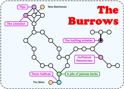
File:Burrows.png
No higher resolution available.
Burrows.png (428 × 306 pixels, file size: 15 KB, MIME type: image/png)
File history
Click on a date/time to view the file as it appeared at that time.
| Date/Time | Thumbnail | Dimensions | User | Comment | |
|---|---|---|---|---|---|
| current | 13:40, 5 September 2012 | | 428 × 306 (15 KB) | Tokai (talk | contribs) | Map - Correctly labelled the exit to the Shire. |
| 13:23, 30 May 2006 |  | 429 × 306 (15 KB) | Tokai (talk | contribs) |
You cannot overwrite this file.
File usage
The following page uses this file: